Biking Trails
The Town of Gibsons and surrounding area have several biking trails for different ages and abilities. Click on the links below to learn more about each one.
Helen’s Way
A low-gradient connector trail between Upper and Lower Gibsons that enables casual hikers and mountain bikers to enjoy nature, right in the heart of our town
The Gibsons Connector
A safer, less steep, paved bike/walk routes between Upper and Lower Gibsons.
Reed Road Multi-Use path
This path runs along Reed Road, between Payne Road and Park Road.
Sprockids Mountain Bike Park (SCRD)
Located at the top of the Gibsons Bypass, at the north end of Stewart Road, Sprockids Mountain Bike Park offers more than 14 km (8.4 mi) of looped trails covering 48.3 hectares (119.33 acres). Click here to view a digital trail map for the Sprockids Mountain Bike Park.
Gibsons and Area Cycling Day Trips Map
What do those symbols mean?
When new active transportation routes are created, we mark them to differentiate them from regular roadways. As some of these pavement markings are new to the Town of Gibsons, we’ve created this visual guide to help cyclists and drivers understand what is expected when they are encountered.
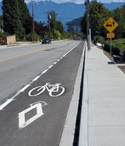
Diamond & Bike
A painted diamond and bike indicate a dedicated bike lane. Vehicles may not drive, stop or park on a bike lane.
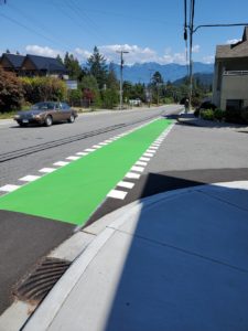
Green Lane
The green paint on the roads is used to raise awareness for motorists and for cyclists that they are entering a potential area of conflict. This would include an area with higher than usual cycling activity and at intersections.
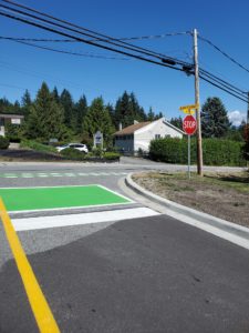
Green Bike Box
A bike box is a green pavement marking installed at intersections to reduce conflicts between people bicycling and driving. People bicycling can stop in the green box to wait for a break in traffic. People driving wait behind the green box for the cyclist to continue on.
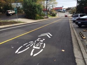
Arrows & Bike (Sharrows)
“Sharrows” are pavement markings that improve cycling safety on streets that are too narrow for traditional bike lanes. These markings indicate to drivers that the road is a preferred bicycle route, and that they should be prepared to share the road with cyclists.
Community Partners
Virtually all of our active transportation projects include input from Transportation Choices – Sunshine Coast (TraC).
We also actively support Sustainable Sunshine Coast, a newly launched initiative spearheaded by Sunshine Coast Tourism, which is focused on encouraging alternative transportation and supporting tourism businesses and experiences that are better for the environment.