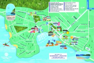
The Town of Gibsons is committed to supporting the development of a comprehensive active transportation network that will enable residents and visitors to safely walk or bike to various locations within the Town.
For those wanting to explore or travel through Gibsons by foot, we suggest a number of self-guided walks, including:
Seawalk
The Seawalk follows the coastline in Lower Gibsons from Armours Beach all the way to the Gibsons Public Market. This trail is a great way to get a sense of the community and the active coastline, populated with sea birds and seals.
White Tower Trail
You will find this trail adjacent to the curling rink and aquatic facilities. It offers easy access to flat, forested multi-use trails, boardwalks and pondscapes. The tranquil ponds alongside the trails are part of Gibsons’ “Natural Asset” inventory, as they play an active role in helping to manage the Town’s stormwater.
Helen’s Way
A low-gradient connector trail between Upper and Lower Gibsons that enables casual hikers and mountain bikers to enjoy nature, right in the heart of our town.
The Bay Walk
From views of the marina down to the lower Bay Area of Lower Gibsons and Seawalk.
The Heritage Walk
Explore the Town’s Heritage Hills neighbourhood.
Inglis Trail
A forested trail which links Lower and Upper Gibsons.
Parkland Trail
A lovely walk that begins at Payne Road taking you through a partly through a forested area and along a berm and pond, ending at Brothers Park.
Walk on Water Interpretive Tour
A self-guided walk that visits sever different points of interest around the Town of Gibsons. Signage at each spot explains the significance of the site and its relation to Aquifer 560.
Visit our Neighbours
The SCRD manages and maintains 16.79 kilometres of paved bike paths, approximately 71.6 kilometres of trails, and 102 beach accesses and community parks with a total size of 698.78 hectares.
-
Sunshine Coast Parks Trail User Guide (mobility friendly)
-
Sunshine Coast Regional District (SCRD) Parks & Trails Interactive Map

