 The Official Community Plan is a statement of objectives and policies that guide Council’s planning and land use management decisions. The OCP is a living document, and adapts to new trends and issues expected to arise over the coming 20-year period, while also responding to the ever changing circumstances in the Town of Gibsons.
Official Community Plans are usually reviewed/refined every five years to ensure that the OCP continues to meet community needs. The Town of Gibsons Smart Plan was first adopted on April 19, 2005.
The Official Community Plan Update was adopted on March 17, 2015, after an 18-month review process. Since then, a number of amendments have been made to the OCP (see list of Amendments on Smart Plan – page 1 and page 2.)
Below, the current version of the Official Community Plan (which reflects all amendments) is provided:
- OCP – Part ABC Smart Plan: Town-wide policies and all Development Permit Areas
- OCP – Part D – Upper Gibsons Neighbourhood Plan
- OCP – Part E – Harbour Area Plan
- OCP – Part F Gospel Rock Neighbourhood Plan
Vision
The Official Community Plan Update established a vision for the future of Gibsons:
Gibsons will continue to be a welcoming, sustainable community that offers residents and visitors an outstanding quality of life in a spectacular natural environment. We will ensure this beautiful town retains its seaside village character for the enjoyment of all and we will nurture our unique cultural heritage and natural assets while supporting opportunities for our local economy.
Land Use Designations
The Land Use Map provides residents, Town staff and Council with direction for growth and change. When considering a zoning amendment application, Council uses the Land Use Map to ensure the zone aligns with the Land Use Plan. If a zoning amendment is not consistent with the plan, an OCP amendment can be applied for.
It should be noted that the Land Use Map is not the Zoning Map. The Zoning Bylaw provides the specific details in relation to height, setbacks and densities for parcels in the Town.
Three main changes were made to the Land Use Plan during the OCP Update. These were:
- expansion of the live/work designation;
- incorporation of the former SCRD lands into the Land Use Plan;
- additional areas of medium-density residential were added specifically along School Road, and Davis/Poplar Roads area.
View the Land Use Designation Plan (map of Gibsons) here.
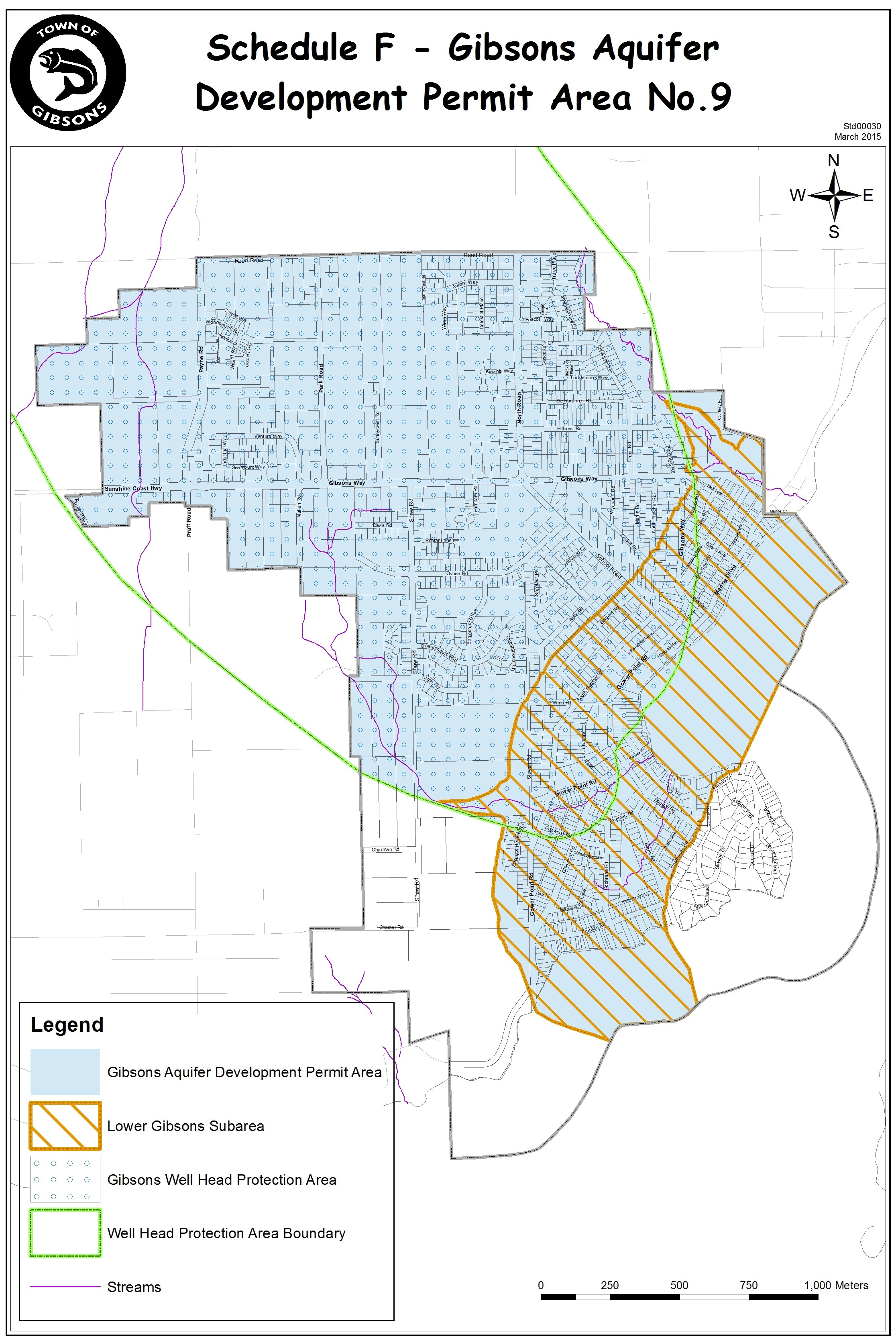
Development Permit Areas
The Town has established Development Permit guidelines to regulate development in the areas designated as Development Permit Areas on Schedules C, D, E, and F.
Schedule C – Geotechnical Hazards DPA 1
Schedule D – Environmentally Sensitive DPA 2
Schedule E – Form and Character DPA 3,4,5,6,7,8,10
Schedule F – Gibsons Aquifer DPA 9
Unless specifically exempted, all properties within Development Permit Areas require a Development Permit prior to:
- Subdivision
- Construction of certain types of buildings or structures (including additions and alterations)
- Alteration of the land (including any removal of vegetation or grading) for properties with the environmentally sensitive or natural hazard Development Permit Areas 1, 2 and 9.
To verify if your project requires Development Permits, please contact the Planning Department.
To apply for a Development Permit, please submit a Development Permit Application to the Town. Development Permit Applications can be found here.
Development Permit Guidelines are as follows:
Development Permit Number 1- Geotechnical Hazard Areas
Development Permit Number 2 – Environmentally Sensitive Areas
Development Permit Number 3 – Upper Gibsons Commercial Area
Development Permit Number 4 – Multi-Unit Residential Development
Development Permit Number 5 – Gibsons Landing – commercial and multi-unit residential development
Development Permit Number 6 – Light Industrial/ Service Commercial
Development Permit Number 7 – Live/ Work
Development Permit Number 8 – Intensive Residential (Cottage/ Cluster/ Garden Suites)
Development Permit Number 9 – Gibsons Aquifer
Development Permit Number 10 – Gospel Rock Village
