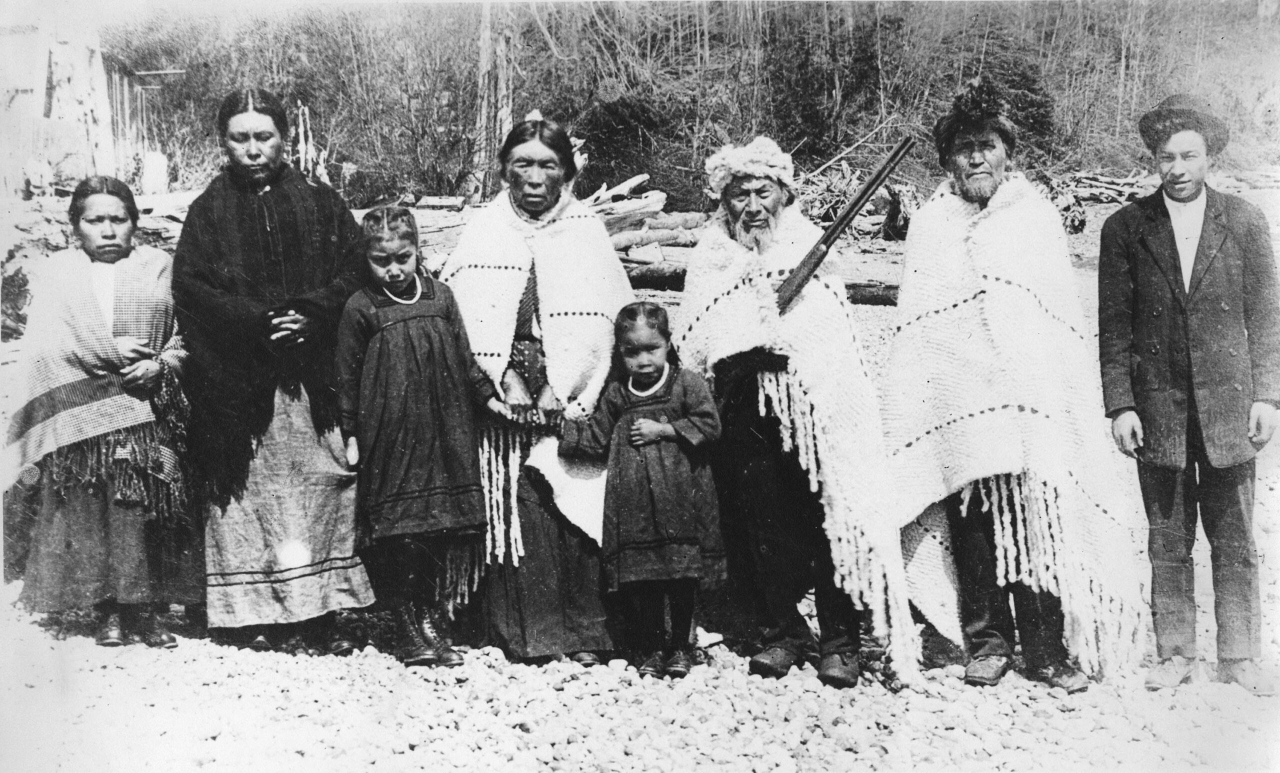
Residents of Ch’kw’elhp Tiyáxeltxw and Syexwáliya (middle) with visiting relations from Squamish, 1913. Vancouver Archives photo: AM54-S4-: LP 192.1
Gibsons, B.C. is located in the southwestern tip of the traditional, unceded territory of the Skwxwú7mesh Úxwumixw (Squamish Nation). The Squamish people have lived in this region since time immemorial.
The Skwxwú7mesh village sites of Ch’ḵw’elhp and Schen̓ḵ are located near present-day Gibsons Landing. Both locations play an important role in the Nation’s creation story, featuring brothers named Ts̓ek̲ánchtn and Sx̲eláltn, and the sacred Sx̲waýxwey dance. For millennia, Skwxwú7mesh have lived in deep connection to the rivers, forests, and mountains of their traditional territory, with place names often reflecting the importance of the land. Stone tool belongings from Ch’ḵw’elhp and Schen̓ḵ have been dated upwards of 8,000 – 10,000 years before present, representing a continuous and long-term occupation of the region. Traditionally an oral culture with ancestral names and stories passed down through the generations, Skwxwú7mesh language is called snichim, and is distinct from neighbouring Nations. [citation – Sḵwx̱wú7mesh Lil’wat Cultural Centre – https://slcc.ca/history/]
It is generally believed that the Spanish were the first Europeans to visit the region, with maps drawn by Captains Galiano and Valdes around 1792. British Captain George Vancouver soon followed: journals kept by Vancouver suggest he went ashore near Chaster Creek. Captain Vancouver meticulously mapped the west coast’s intricate inlets and shorelines. With the growing expansion of colonialism in the 1700 and 1800s, small pox ravaged First Nation populations.
The first European to settle in Skwxwú7mesh territory near Ch’ḵw’elhp was George Gibson, an ex-British naval officer. George and his sons built the Swamp Angel and sailed to Átl’ka7tsem Howe Sound where they pre-empted (claimed) District Lot 686 in 1886. Within two years, Gibson had built a two-storey house, planted 100 fruit trees and cultivated four acres of land, enough to ship his produce to Vancouver to sell, and enticed other early pre-emptors including the Soames, Winegarden and Glassford families. From 1886 to 1910, much of the area was pre-empted by settlers as the population grew. Like much of British Columbia, the land was settled without treaties being signed with the host First Nations, which is why the term unceded territory is commonly used.
Gibsons Landing was dependent on water transportation and contact with the outside world was maintained by tug-boats. In 1891 the Union Steamship Company began to call at the dock, making the area more accessible.
The mainstay of employment for the early pioneers was related to logging and the production of shakes or shingles. When fishing or logging was not productive, residents practiced subsistence agriculture to make ends meet. “Stump farming” as it was locally known, required the blasting out of tree stumps in order to create an appropriate landscape to farm.
As the population grew between 1910 -1930, shops and services such as a bakery, a delivery service, a post office and drug store sprung up in the landing. An important development during this time was the arrival of Finnish settlers, many of whom had left the failed utopian community of Sointula on Malcolm Island. Looking for a place to homestead, between 14 and 18 Finnish families settled in the Gibsons area during this time, introducing the co-operative organizational model which would be used to develop successful local businesses such as the Howe Sound Cooperative Cannery.
Through World War II, Gibsons Landing remained a small rural community based on logging, fishing and a limited amount of agriculture. After the construction of a road from Gibsons to Port Mellon around 1950, the Mill became one of the largest employers for Gibson’s residents. In 1951 a car ferry service, Black Ball Ferries (later to become BC Ferries) began, resulting in relative ease of travel from the Lower Mainland by car. In the next few years, the roads between the various communities on the Sunshine Coast were paved and improved which encouraged commerce between these areas as well as with Vancouver.
At this point, growth became much more rapid. Much of the more recent development in Gibsons has occurred in “Upper Gibsons”, where flat land allowed expansion and adequate parking compared to the old business area around the wharf at the waterfront. This trend in development continued, and today most commercial activity is located in Upper Gibsons while the waterfront has become more oriented towards tourism and cultural activities.
Source: Sunshine Coast Museum and Archives
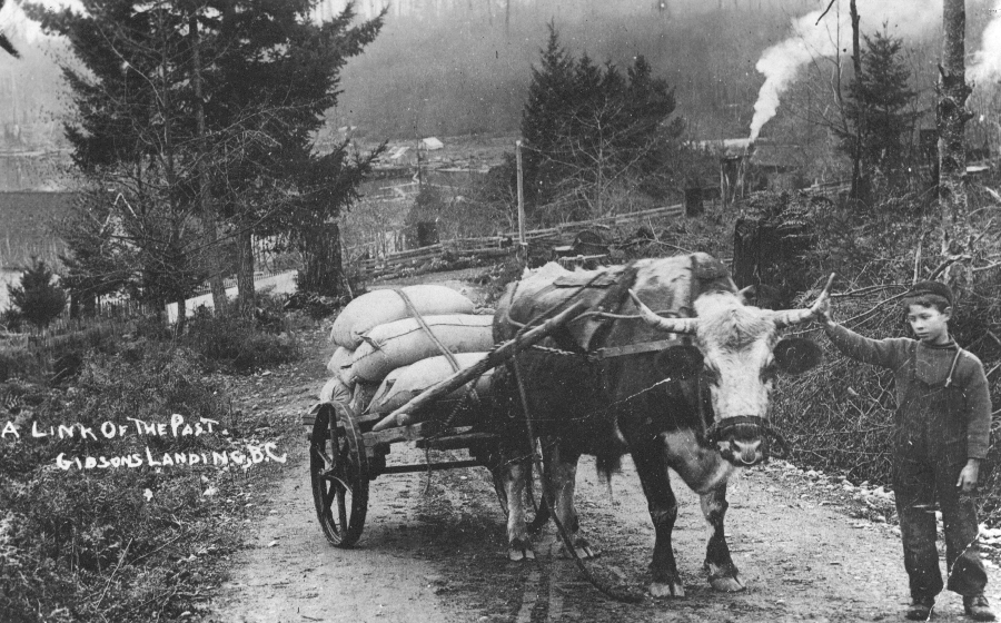
Photo #246 – Gibsons Landing c1913. John Wyngaert, with family ox “Billy”, hauling supplies from the wharf to home. Steam is from Cross & Armstrong sawmill in the bay area. Methodist Church at left. School Road along fence. Ox purchased from George Gibson. Postcard.
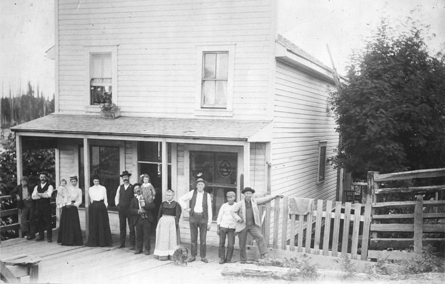
Photo #950 – Gibsons Landing, circa 1905. Store built at head of wharf by George Gibson Sr. in 1900. It burned down in 1910.
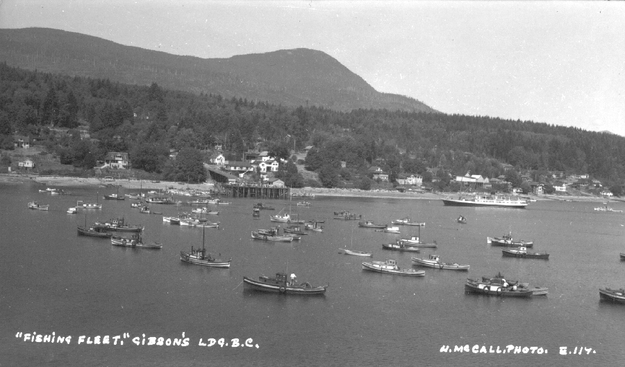
Photo #3556 – A view of the fishing fleet anchored in Gibsons harbor waiting for the area opening. Taken from the Bluff looking across the harbor to the wharf, circa 1930. A Union Steamship Co. vessel approaches the wharf.
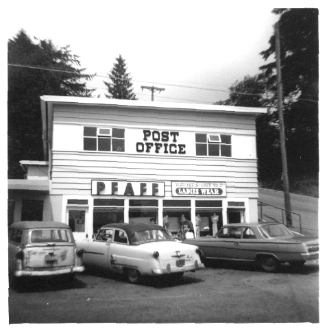
Photo #174 – The Gibsons Landing post office at the corner of School Road and Gower Point Road, circa 1962, just before move to new location at corner of Winn Road.
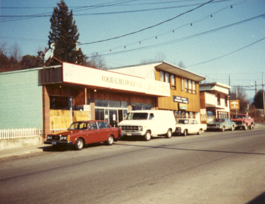
Photo #1868 – A colour photo of the businesses on the north side of Gower Point Road, just west of the main intersection. The Heron Cafe, Florest and Gifts, Gibsons Landing Professional Building, Hunter Gallery, Granny’s Sweets, N.D. P. Bookstore.
Photos courtesy of the Sunshine Coast Museum and Archives.