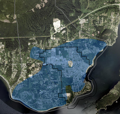
Aquifer 560 is a high-quality confined aquifer located below the Town and extending beyond the Town boundary into the Sunshine Coast Regional District (shown as blue in the map below). The aquifer acts as a natural underground reservoir that holds and provides groundwater to our wells.
100% of the Town of Gibsons depends on groundwater from the aquifer, which is pumped from three wells located in Lower Gibsons and one well in Upper Gibsons.
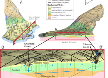
The watersheds (the water sources that fill the aquifer) include Charman Creek, Chaster Creek, Gibson Creek and Soames Creek. The headwaters for all four watersheds originate along the south facing slope of Mount Elphinstone at an elevation of greater than 1,100 metres above sea level and all drain into the Salish Sea.
The Town has extensive data to understand the movement and cycling of water in the Aquifer and is able to assess the long-term supply under various demand and climate conditions. The Town’s annual monitoring program provides information on water level, water quality and recharging levels, tracking trends year to year.
The Town’s water distribution system records the volume of water pumped from each well hourly, and the sensors in the well provide staff with real-time data of the water level at each of the well locations, allowing staff to monitor the aquifer continually.
Did you know?
- The aquifer is a “natural asset” which provides municipal services, such as water storage and water filtration, in the same way that engineered assets do.
- The aquifer is gravel and sand that is saturated by water (not an underground lake or river)
- Groundwater is not static; it moves underground, sometimes very slowly. The space between the gravel and sand particles in the aquifer determines how fast a drop of rain travels from the base of Mt. Elphinstone underground to Lower Gibsons; based on the Aquifer Mapping Study, this may be as long as 10 years.